The Weather Channel reports:
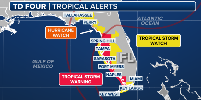
The latest National Hurricane Center forecast shows this system becoming Tropical Storm Debby on Saturday or Saturday night. It will then head toward a landfall in Florida’s Big Bend region on Sunday night or Monday morning as either a strong tropical storm or possibly a Category 1 hurricane. It’s important to note that impacts from this system will be felt across much of the Florida Peninsula, and not just where the system makes landfall.
From there, future Debby is forecast to track near the Southeast coast early next week, where it could intensify again assuming it remains over water. There is an increasing possibility this system might slow down or even stall., which could prolong impacts, especially flooding rain. A hurricane watch is in effect for a part of the Florida’s Big Bend, from Aucilla River to Yankeetown. Tropical storm warnings and watches cover the rest of western Florida.
Tampa’s ABC affiliate reports:
Some counties and cities across the Tampa Bay area opened up free sandbag locations to help residents prepare for the possibility of heavy rains and flooding this weekend.
Hillsborough County residents are eligible for a maximum of 10 sandbags per family at all locations and must show ID verifying they live in the county.
In Pasco County, all sandbag locations are self-serve and open to Pasco County residents. Sand and sandbags will be restocked daily, weather permitting. Please bring a shovel and be prepared to fill your own sandbags.
The Tallahassee Democrat reports:
Florida Gov. Ron DeSantis Thursday declared a state of emergency Thursday for 54 counties. Seven more counties were added late Friday, putting 61 of Florida’s 67 counties under a state of emergency. The depression is moving toward the west-northwest near 16 mph. A turn toward the northwest is forecast today, followed by a northward motion on Sunday and then a slower northeastward motion Sunday night and Monday.
Hurricane conditions are possible in the hurricane watch area by Sunday night, with tropical storm conditions possible earlier on Sunday. Tropical storm conditions are expected to spread northward over the warning areas beginning later today and continuing through Sunday. Tropical storm conditions are possible in the watch area in the Florida Keys later today or tonight, and in the Florida Panhandle by late Sunday.
This morning, Weather Channel hosts are advising that “rapid intensification” is possible due to the record warmth of Gulf waters.
TRACKING THE TROPICS: SATURDAY MORNING UPDATE
• Tropical Depression 4 is expected to become Tropical Storm Debby today
• Tracks north toward Florida Big Bend region, could be a hurricane
• Low shear, very warm water in the Gulf create ideal conditions for intensification… pic.twitter.com/OdqmRBigtC
— Josh Marthers (@joshmarthers) August 3, 2024
Hurricane and Tropical Storm warnings are up for the coast of Florida where Debby will be making landfall in a few days. Models have been trending further west which would give the storm some more time over water to get stronger. This also has greater implications for the entire… pic.twitter.com/NFGuFoCbl1
— Nicholas Isabella (@NycStormChaser) August 3, 2024
A Hurricane Watch has been issued Saturday for a portion of the Florida Gulf coast in the path of a storm that is expected to strengthen into Debby before making landfall on Monday.https://t.co/jRbCJYJF8J
— Sonia Osorio (@soniaosoriog) August 3, 2024
We now have Tropical Depression Four over Cuba this morning. It will intensify into Tropical Storm #Debby this weekend in the eastern Gulf of Mexico. A farther west track means more time over water and more time for strengthening. Hurricane Watches added for Big Bend of Florida. pic.twitter.com/NL7ZUC3ANp
— Collin Gross (@CollinGrossWx) August 3, 2024